Tuesday, August 24, 2010

Reno To Home

Sunday August 22

Made less than 200 miles today, owing to a late start, a stop for breakfast, realizing just in time that the campground I was aiming for is in Bishop, not Lone Pine, and that it was 100 degrees when we got here. Bishop, Independence, Big Pine, and Lone Pine, in the eastern Sierras are terrific little towns, and tonight we vowed to come up here for a weekend soon. This place, Brown’s RV Park, is a beautiful, shaded park right next to a nice golf course. There are several good restaurants in town, as well as bakeries (including Eric Schatt’s), a smoke-house (meats, not pot), an independent bookstore, lots of hiking, and a small casino. In the fall the weather will be much better. We usually blow through here on our way to visit daughter Carol in Incline Village, but it deserves a weekend. 
US 395 between home and Reno is one of our favorite drives for scenery; we have the new Scott Turow novel on the DC player (thanks to Arnie and Diane), and we had ice-water and hot coffee to sip. There is a lot of construction on northern part of this route. Apparently Nevada got more out of TARP than Sharron Engle and Sara Palin have noticed. The improvements on 395 (and you should see the project at the junction of 395 and I-80) will eventually will be a very good thing, but the signage could be improved. We got goofed up at a detour and ended up on NV 431 headed up Mt. Rose and had to make a U-turn (YIKES), and go back to the beginning. So it was after 11 before we got going in the right direction this morning.
It’s been a great trip, despite the mechanical problems. Steve is going to talk to our usual repair guy, whose techs supposedly packed the bearings and checked the brakes before we left. They also washed and waxed the trailer, which looked great until we noticed they had missed whole sections – especially the nasty black marks on the seals. We’d like to keep using them, but need some assurance that they will pay better attention.
It’s hard to say what our favorite place was. Steve’s are Fort Worden and Victoria. I agree. Seven Feathers casino RV park is up there on the list as well. For scenery I pick Columbia Gorge, despite having crummy accommodations while we were there. Westport, OR would be wonderful if it’s not 50 degrees and raining, as well.  
No internet again tonight, so this last blog post for 2010 will have to wait until I get home. Home is about 270 miles, and we’ll make it tomorrow for sure, hopefully by getting an early start so that most of the Mojave is behind us early in the day and we’re down the I-5 before rush-hour.

Tuesday August 24 Post-Script
When we're on a long trip, we know we're almost home when se see the Joshua trees
Arrived home early yeserday after easy 270 miles from Bishop. It was hot, but very little traffic. It's good to be home.
Thanks for reading!

Saturday, August 21, 2010

Reno, NV

Hello from Reno! Steve is enjoying the Kiwanis convention and I've taken the two days to get the trailer thoroughly cleaned, decreasing my work once we're home by about 50%. Also got some "girl-maintenance" done on my hair.

We also saw Carol and Jay last night. They took us to a wonderful Indian restaurant on South Virginia Street near the capital. Food was excellent. Ate the leftovers for my birthday brunch! Yes, it is my 64th birthday. In less than one year I will be on Medicare. It's my birthday, so I can eat goscht korma with rice and naan at 10:30 AM if I want to!

It was almost 100 degrees the last two days, but it's cooler today and an angry-looking storm is blowing in. Locals tell me it will likely pass over with maybe a thunder-clap and and a few drops.

We leave for Moorpark tomorrow morning and will most-likely stay in Lone Pine tomorrow night. 500 miles is just too far to go in one day pulling the trailer. We're looking forward to being home.

Thursday, August 19, 2010

Likely, CA to Reno, NV

Easy drive today from Likely to Reno. The picture is of our first glimpse of the Sierras as we traveled down I-395.

We are at the Grand Sierra Resort and Casino in their very dumpy RV park which is more like a parking lot. It isn't very hot, but There's a dog show at the hotel this weekend, so they expect a full house. We're wondering if we can't enter Doogie in the dirtiest dog part of the contest, but there is more-likely going to be a park full of newly-groomed fussy little show dogs. Speaking of Doogie, we'll be glad to get home to the vet. He's had a good trip, but I'm worried that he's not himself the past few days. He has some stomach upset and is really feeling the heat. I have antibiotics for his tummy, but they're not kicking in like they should. We'll be home Monday and will get him checked out, for sure.

Burns, OR to Likely, CA

After hitting the large and very nice quilt shop in Burns, OR where I scored a bunch of fabric quarters for the quilt I want to make, we hit 395 south again, hoping to make about 150 miles today. Fortunately, today the road was straight and flat, making it a much easier drive for Steve, who will no longer let me drive the trailer as, although he won’t admit it, he thinks I fried the brakes. Not driving the trailer is not a problem for me; I have no feminist need to prove that I can handle it. I got over that stuff many years ago when I had a flat tire on the way to work one bitter snowy day in Connecticut. As I rummaged in the trunk trying to pry the spare and the tools out of their little well without bashing my frozen fingers, a man who was running toward me shouted, “Honey, don’t touch that. Those tools are dangerous.” Of course my first reaction was, “Go away, you moron.”But I caught myself just in time and realized that the temperature hovered near zero, and if this man wanted to change my tire, I’d be a moron to stop him.


Anyway, today was a much easier drive and we made 200 miles. Crossing the giant caldera that is the Great Basin, at first the landscape is flat desert with pointed mountains that look like inverted snow-cone cups. There are warm springs to the east, and we could see alkali deposits and passed sand dunes and several drying salt lakes. It was desolate, sparsely traveled, and very beautiful. About 100 miles down we came across a rest-stop that had very nice exhibits of the geology, wildlife, and native inhabitants of the region. Toward the southern end, as we crossed into California, the sage greened up as the landscape changed to farmland - alfalfa, wild rice, and bales of hay.


Tonight we’re in the Likely, California RV and Golf Resort. The last photo is the view from our campsite. Likely is miles from nowhere - many miles. The “resort” itself is several miles from Likely, off 395. I had found it by accident reading reviews of the crappy (not to mention few and far between) RV parks along I-395 north of Reno. Likely is about 20 miles south of Altura (160 miles north of Reno), and someone had a dream of a nice resort for RV-ers and made a little RV park next to a regulation-length golf course at 4500 feet here in the very far boonies. It is quite nice and the best option for miles around but it is only ¼ full tonight. There are no signs to the place so if you don’t know it’s here, you’d never find it.

We’re less than a day’s drive from Reno tonight and will be there a day early. It will give Steve a chance to relax before the convention. The little sore throat I may have mentioned has blossomed into a full-blown chest cold, so a couple of days of rest for me.

Tuesday, August 17, 2010

Pendleton to Burns, OR

We wondered why Google Maps always directed us to take I-84 to Rt 95 through Winnemucca to get to Reno. Now we know. Today we made 200 miles in a mere 7 1/2 hours over the eastern Cascades. Up and down 5000 feet to sea-level and back again. 70 degrees to 95 degrees and back again, spending most of the day in the Malheur National Forest. Switch-backs and climbing - breaking hard down the mountains. I-395 is a two-lane road here, recently paved and smooth, but it's a white-knuckle drive all the way. Double-trailer log trucks sped past us going northward and going very fast - obviously familiar with the curvy, narrow road.

 We drove through brown plains dotted with basalt, climbed pine-covered mountain, crawled through tiny towns (with no gas stations). A few farms appeared, mostly working on bringing in the hay. We crossed the 45th parallel (there's a sign) half-way between the equator and the North Pole. Toward the southern end of our route, we passed into Mojave-like grasslands and granite, not basalt formations. The temperature climbed and puffy white clouds became thunderheads that became squalls here in Burns.

So Google Maps was probably right. The longer route is the faster and more comfortable. Never mind about that now; we're committed to I-395. Steve met a guy here at the campground who is headed north and from what he said we're in for the same kind of day tomorrow. The scenery is beautiful, though.

We did a ton of laundry, sauteed some pork chops with a nice wine reduction, and have good internet and good phone access tonight. All in all, a good day. 

Monday, August 16, 2010

Cascade Locks to Pendleton, OR

We left Lewis and Clark land this morning, retracing their steps east along good old route I-84 (I think I've written that we used to live at the other end of it in New England) which parallels the Columbia for about 150 miles. Just past Hood River, the dense green forests quickly gave way to golden hills and basalt formations leaning toward the Pacific. We've recently learned the river gorge area and these huge rock formations were carved by the great Missoula River flood many eons ago. By the time we reached The Dalles, around 10:00 AM, it was 86 degrees and the landscape was more Mojave than what those of us who have never been to eastern Oregon think of the Pacific Northwest.

We followed the wide river through delta of the Deschutes Valley where windmill farms dot the brown hills and many small boats fished the river, past dams and silos full of grain waiting for barges. There are a few sparsely populated towns but the whole Columbia River Valley is basically unspoiled.

When the temperature reached the 90s we turned away from the river and headed southeast where the hills flattened into a plain that felt like West Texas without Octotillo. No trees live as far as you can see; the sun just beats down on everything. Here and there huge rock formations - basalt from the ancient floods - sit on the fields.

In Irrigon (for irrigated Oregon, we think), there are suddenly farms and stands of Pacific Arbus, a deciduous looking hard-wood, lined up in neat rows with signs indicating the planting dates. Then grain bales stacked along the road and, in one place, thick smoke of fires burning the residual wheat that the threshers left. The  fields are burned meticulously, leaving neat squares of blackened earth. We passed corn, sheep, cattle farms, an grasslands.

Pendleton is the junction of I-395 and I-84. We've here stopped for the night at the Indian casino and RV park run by three tribes. Of course, we hit the casino right away. It's a nice little place - low stakes, lots of blue-hairs, and friendly. After loosing the obligatory $20 in the slots, we played $2 blackjack for two hours and broke even, thereby setting a family record! Then we hit the buffet (like all the other blue-hairs). Once the sun set, the temperature dropped about 40 degrees. It's quiet and will be a comfortable sleeping night, which is good because tomorrow we have to make at least 200 miles through mostly isolated desert, so it will be a tough driving day. The last campground we stayed at was next to a train track used by long freight trains about once per hour all night. The trains were literally 50 feet from our heads. We can hear a train in the distance now (probably the same one); fortunately it won't be blowing it's horn next to us.  


Sunday, August 15, 2010

Cascade Locks, OR

You'd think that being in Bill Gates' back yard that there would be good, strong, wireless all over the Pacific Northwest. But there isn't. There's better coverage in the far boonies (and we've been to the far boonies) than there is here. You don't now how much you depend on the net until you don't have it for a while. I'm going to write KOA a letter about their "free internet"; I would pay for it if it worked! Anyway, we're sitting on the deck of a marina, with good internet, overlooking the Cascade River, just north of Bonneville Dam. It's clear and very hot for this area (was 99 at 7PM last night), but there's a 20 knot wind so it feels cooler. This is the life. Yesterday we took a cruise of the river on a paddle boat. Start the video to see highlights.


We also visited Bonneville Dam and the fish hatchery, a huge and very interesting self-guided tour. Then we went to Multonah Falls for a BBQ dinner buffet - worst dinner we've had in a long time! The first problem was the fly in my shrimp; the waitress replaced my plate and I went through the line again. The second problem was that everything was over-cooked. With ribs it doesn't matter so much, but the salmon fell apart, the buffalo brats (which Steve had been looking forward to) had great flavor but were dry as wallboard.   
Then the decaf was cold and the cream curdled. By the time we got the coffee,we were tired of complaining, so we just paid the bill, wrote a long missive on their QA form and left. Oh well.

This morning we walked out on Robinson Island and let Doogie break the law for a few minutes by running off-leash to burn of some energy before it gets hot again. This afternoon we're going to tour some of the Lewis and Clark Historic sites then head out I-84 to I-395 toward Reno. We'll be glad to get home.


Thursday, August 12, 2010

Sprained, Not Broken

There are electricity projects along route 12 in south central Washington. The Tacoma Power Company has built several dams. Each dam, there are at least four in the area, comes complete with a wonderful state park complete with fishing bridges, huge full-service campgrounds, playgrounds for children, a swimming area, and trails to hike. The facilities are wonderful and the scenery is gorgeous – clean lake, beautiful skies, a deep forest…quiet and peaceful.

We opted for Taidnanam, the park closest to Mt. Rainier. We think, but are not able to verify, that when the power company wanted to dam the rivers, the state made them provide the parks. Although the reservation for the campgrounds is through the state reservation system, the employees don’t seem to be state rangers. Checking in on Tuesday, we had our pick of a mostly empty park. Shortly after making camp we checked out the fishing bridge and boat ramp. People were lined up on both sides of a pedestrian-only bridge, catching trout. The boat launch was deserted, giving us a chance to give Doogie a short swim before Steve had his first mishap, turning his ankle on the rough pavement on the boat launch. He limped around for a few minutes, and then was fine.

Steve’s second mishap came as we were preparing to head out for an after-dinner stroll. He stepped out of the trailer and turned the same ankle, only this time he really turned it and fell into the leaves and dirt. He was in severe pain, covered with forest debris, and couldn’t walk. We could feel it swelling through his sock. So here we are, fifteen miles from Morton, Washington, which is not exactly nowhere, but you can see it from here. No cell reception. No internet. So we got him into a chair, determined that he could bear a little weight without collapsing, and then hoisted him into the trailer.

First the trailer. Now Steve. What a trip!

Fortunately I read the study published a couple of years ago that concluded an x-ray is not necessary first-line treatment for an ankle injury; ice, Ibuprophen, an ace bandage, and elevation being the better strategy. If something is broken, waiting 24 hours won’t make it worse. So we decided to tough it out. He was in such pain that I really worried about it, but after 400 of ibuprophen he was lots better, and by morning he was able to walk a little. We did go up on the mountain, and though we couldn’t go for even a short walk, we enjoyed the scenery and had a nice lunch in the lodge (green chile and chicken stew (my fave, and blackberry pie al a mode for desert).


So last night we had Girl Scout dinner. We started a fire (Although not in the Girl Scout way; we used charcoal and lighter fluid. Let's keep perspective here.). I cut a couple of potatoes into thin slices, tossed them in olive oil, salt, and pepper, wrapped it all in a foil envelope and cooked them 40 minutes on the coals. Likewise with a few carrots – salt, pepper, butter, dried basil, foil envelope, 40 minutes on the coals….delicioso! It’s even better with a little grated onion and garlic, but I was too lazy. And a wonderful fruit salad for desert – cantaloupe, grapes, and blueberries simply tossed together.

And Steve’s ankle is almost 100%, and my sore throat is feeling a little better. And it’s almost 10PM and we’re not wearing two sweatshirts! It’s warmer at last..

Interesting factoid: Aldus Manutius the Elder (1450-1515) invented the semi-colon! Bet you didn’t know that. You’ve got to read Eats, Shoots & Leaves. Lynn Truss, Penguin Books, 2003. It is just hilarious.

So this morning the ankle was hurting again, so we opted to chill today. We're in a coffee shop in Morton checking messages and trying to figure out how to get from Cascade Locks, OR to Reno, RV easily. We will head back to the trailer soon to elevate and ice. The campsite is deep in the woods and is quiet and restful as well as being very pretty to look at. Next post will be from Cascade Locks, Oregon on Friday or Saturday.

Sunday, August 8, 2010

Tacoma, Washington

Well, here we are again in the Seattle/Tacoma area. After leaving Westport this morning we visited what is becoming our favorite Camping World, just north of Tacoma, and bought a new automatic hitch tongue jack (the thing that lifts the trailer onto the trailer hitch on Mary, our tow truck). Steve had installed our original automatic jack himself, so we thought it would be simple to just pop it in right there in the Camping World parking lot where the pavement is flat. You just drop it into the holes, bolt it down, install a wire to the power source, put in a couple of fuses, ground it somewhere and you're good to go.

Naturally, it turned out to be completely impossible. There are two, 2 1/4 inch holes on the A-frame of the trailer that the shaft of the device has to fit through and they are just a smidgen off plane - like 1/64 of an inch.  So we took the old one off, discovered we can't fit the new one in, put the old one in again, jacked up the trailer a little with the emergency hand-crank, took the old one out, still couldn't fit the new one in, filed down the lip of the new one a little, and found it still wouldn't fit, and once we had tools all over the parking lot and were completely covered with grease, we made an appointment to have the damn thing installed tomorrow at Camping World. We can see that there is enough room for it, but the stupid thing just won't go through. If we had the right tools it would take 15 minutes. But we don't. So now we're in the KOA in Tacoma. Of course Camping World can't fit us in until tomorrow at 2:00 PM so we'll be here 2 nights. It's not all bad. We can do all our rainy-beach-weather laundry (lots of jeans, sweatshirts, dog-towels, etc) purge the trailer and truck of sand and mud and run Mary, who is filthy, through a car-wash.

Then we head for Mt. Rainier. The Tacoma Power Company has three campgrounds around reservoirs off Route 12 that sound terrific. So we're headed for Taidnapam, near Morton, WA. And we'll be close enough to see Mt. Rainier as day trips to avoid the curvy mountain roads with the trailer.

Jeanandsteve2010 itinerary update: we have decided to go to the Kiwanis Convention in Reno August 19-21. Yes. We'll be at a Kiwanis convention on my birthday. But the good news is that we hope to be able to spend a little time with daughter Carol in Incline Village either before or after the convention. We'll head south through the eastern Sierras on I-395 August 22 or 23 and be in Moorpark by the end of the week.

Hopefully some nice pictures next post, which might be after the Mt. Rainier trip. No internet at the power company facilities, I'm sure.

Saturday, August 7, 2010

Rain in Westport

No pictures today because it rained hard all day long. Had no cell and only spotty internet. We went out for pancakes, played scrabble, then went to see them weigh the salmon and tuna for the local fishing derby. The charter companies compete with each other, making the fishing customers on each boat into a team. The five largest fish caught on each boat are entered into the derby. The schools of salmon and tuna have been running about 35 miles off-shore, which, I was told, is pretty far in for tuna. Everyone who came off a boat was wearing a black or orange  rubber dry suit and most were carrying very large fish or coolers full of very large fish. The catch is processed by the local cannery and donated to the homeless feeding programs statewide. Three huge blue tubs full of crushed ice waited at the end of the docks. Average tuna size seemed to be 23 pounds dressed. It seemed that everyone in town came out in the rain to watch the weigh-in. It's a weekend event; final scores will be tomorrow afternoon. Looks like it would be wonderful fun.

Friday, August 6, 2010

Comments

Click on the pencil icon if you want to comment. This is fixed, at last.

Westport Pictures

Crabbing on the Pier

Westport Harbor
Pier Around Harbor
Red to Right Returning
Westport Light 1898
135 Steps Up

Westport Light and Pacific Beach

Woke to rain this morning and it drizzled off and on all day. When the sun peeked through the fog it was quite warm, otherwise cool and misty. We walked out on the pier that surrounds the harbor, then climbed to the top of the lighthouse built in 1898, and finally walked on the wide black-sand beach looking for sand-dollars and scallop shells.

This is a great little town. It reminds me of the Jersey Shore; York, Maine; or Plum Island, Mass...but in November.

The local supermarket gets fish off the boats every morning. How nice! We had a pan-roasted salmon filet with a white wine reduction, fresh local zucchini with Italian herbs, and fresh local salad for dinner. The salmon was swimming this morning and tasted mild and sweet - completely different than any salmon we've ever eaten.

Thursday, August 5, 2010

Hoh Rain Forest to Westport, Wasington

Today we planned a 120-odd mile trip to western WA with stops at the Hoh Rain Forest, Ruby Beach, and the 14-foot rain gauge along the way. We did stop briefly at Hoh Rain Forest, a mere 17 miles off route 101. About an hour each way along a winding, narrow road, pulling our trailer, and so not much fun. The road follows the Hoh river, glacier-fed and teal-blue which meanders through a meadow by the road. The trees and understory are dense and covered with hanging moss. It was only about 60 degrees with the sun poking through the fog and very humid. We only got these two shots before the battery in the camera died. I had been meaning to change it. Sorry.


In the above image, you're looking down on a little stream. The rocks are covered with moss and the water is absolutely crystal clear.

On the drive we saw a bunch of black-tailed deer, which are everywhere in the peninsula, a lot of creepy crows, and a baby bear who ran across the road in front of us. We've been on the peninsula about 10 days, mostly along 101, and have passed three prisons in the past 200 miles. Prisons are called "Correction Centers". Isn't that kind of a funny name? Correct what?

The trip was the longest 120-something miles! It took all day. But we arrived in Westport and have a nice campsite. It's cold and foggy like everywhere else on the peninsula. The campground manager told me they've only had 5 sunny days all summer. Westport is a cute beach town and we will enjoy it. Sampled one of the local restaurants and had a wonderful dinner. Clam chowder and deep-fried Dungenous crab. Deep fried crab!!! Oy Vey! Was it good! We better go for a long walk tomorrow.

Wednesday, August 4, 2010

Forks, Washington

Rialto Beach

Rialto (some maps have it as Mora Beach) 17 miles from Forks, is part of the Olympic National Park Coastline section. We were there at noontime, and the sun was just trying to peak through the fog and clouds. Temperature about 55 degrees.


The beach is shallow and covered with smooth gray stones and enormous piles of bleached driftwood that most-likely floated in left-over from logging. There are signs warning that the beaches in some places disappear at high tide and that hikers must mind the water level and direction of the tides. Just north is a high headland that the signage indicates hikers must climb to avoid being swept away. We walked a little, but the stones make footage difficult and we didn't get very far. Doogie ran around in complete joy. Put that doodle on a beach and he's a happy boy.


Heading back to Forks, we stopped at a little luncheonette and I indulged in fried, fresh, local oysters. Don and Janet, in the trailer next to us, whom we met at the KOA campground in Sequim, bought a whole salmon, caught this morning, from a local who put out a "fresh fish" sign in his yard. He paid $3.00 a pound and is butchering it himself. I almost bought one yesterday, but they weigh almost 10 pounds, and I'm really intimidated at the thought of filleting it myself. Steve isn't crazy about salmon, gets turned off by the bones, and I'm afraid I would end up throwing half of it away. The only pliers we have with us are not approriate for pulling pin bones off a salmon fillet, and the small freezer in the trailer is not dependably cold enough.

We're heading south tomorrow. First stop, Westport, WA on the southern, western tip of Washington State. It'll be another three days in cold foggy weather, but we're enjoying the beaches and little towns. On the way we will visit the Hoh rain forest and Ruby beach. On Sunday we'll head southeast into Oregon to the Columbia Gorge. After that we'll head more due south and be slowly homeward bound.

Tuesday, August 3, 2010

Neah Bay, Washington


Neah Bay, on the Makah Reservation, is the northwestern most point in the continental US. We drove out from Port Angeles, hauling the trailer, originally planning to stay a couple of days. You take 101 west to the 113, to the 112 and drive slowly around switchbacks and up and down hills for 100 miles. The ocean with log-strewn sandy beaches, sea stacks, and tide-pools is on your right and level with the road for about 70 of those miles. The roads pass through Clallam Bay and Seiku, finally ending at the town of Neah Bay. From there, the RV resort is another few miles toward the south to Cape Flattery, on a dusty gravel road. The "resort" (another relative term) is a gravel parking lot with several cabins and a few RV hookups. The beach is spectacular, but we didn't stay. For one thing, at 1:00 PM, the temperature was 55 degrees and the air was thick with fog, while just a mile or two inland it was sunny and in the high 60s. The other reason was that it was a little creepy. I felt isolated and vulnerable. Steve and I were both trying to second-guess what the other wanted to do, and we finally agreed to head south to a slightly more populated area.

So here we are in Forks. The "Twilight" capital of the world. Apparently there is a TV show about the town. As we are not much into vampires, we had never heard of it. There is access to the beaches just a few miles up the road, so we're going to stay for a couple of days and check it out. After several active days, we're ready for a day of relative quiet.

I found a nice little produce market selling local corn and local mushrooms so we had a nice dinner. We even plugged in the TV and watched the news. Connecticut sure made headlines. I used to work right near there. Yikes.  

By the way, what is the deal with the numbers on the back of the social security cards? Can someone please email me and explain what craziness is afoot about it?


Monday, August 2, 2010

Olympic National Park

Spent the day touring the Port Angeles, Sequim (pronounced skwim) area. Most of ONP is a temperate rain forest. Temperate is a relative term, as I have been freezing to death the whole time we've been here. The fog burns off and the sun comes out about noon and it warms up to almost 70. By 3:00 the fog is rolling in again. Last night is was a balmy 48 degrees in our campsite when we went to bed. I slept in pj's, socks, a long-sleeved T, and a hooded sweatshirt. Cozy!

Olympic Mountain Range

The snow lasts until August


The white thing is a glacier.

The Olympic peninsula has the clearest, bluest skies you've ever seen. Although there is a web of fog covering everything most of the day, when the sun dries the mist the air is crisp, cool, and clean. From the top of Hurricane Ridge you can see across Juan de Fuca all the way to Victoria. The mountains look like the pictures of Switzerland. Parts of the peninsula, like Sequim, get only 14 inches of rain a year. Other parts just a few miles away get 14 feet a year!

After the morning at ONP, we traveled back through Squim to see the museum of the Jamestown Band of S'Clallam Indians. They have a beautiful building on one side of 101 that houses the museum, and a casino on the other side of 101. Skipping the casino (we've still got our $375 from Seven Feathers), we headed for the museum, which was a huge disappointment. There were a few artifacts, but most of it was a gigantic gift shop selling the same imported crapola you see everywhere. We did catch the tail end of a tour and learned that the S'Clallam are "strong people".  According to one legend, twS'Clallam men were strong enough to lift a huge log from the ocean. You would have to be strong to live here without central heating, believe me.  

Tomorrow we're going to move on to the western part of the peninsula - Clallam or Neah Bay - and I'm not sure how long we're staying. It's pretty remote, and internet may be a challenge. What we do may depend on the weather. Although we've loved it here and will be sad to leave, I'm ready for some warmth.  

Jean and Steve's Excellent Victoria, BC Adventure

Parliament Buildings

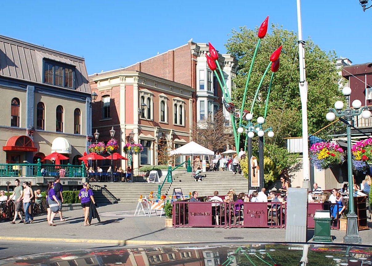
Victoria, BC is an hour from Port Angeles, WA by ferry and was a wonderful weekend side-trip. We were anxious about visiting a big city with a dog, but we needn't have worried. Our cute little hotel, just steps from the customs office was very welcoming, and while most of the tour buses didn't allow dogs, the "Big Red Bus" is dog-friendly. The people were also "dog-friendly". Everywhere we went someone wanted to pet Doogie. He had a blast.

Enjoying the "Big Red Bus"

Baskets of Flowers from Every Lamppost

Resting at a cafe


Bastion Square - typical of the city with cafes everywhere

Victoria Waterfront
Many Beautiful Gardens

Parliament

Butchart Gardens

Canadian Sunset

Butchart Gardens

Downtown Victoria


Parliament by Night

Weather was cool but sunny most of the time. We took an on-and-off tour bus, but walked miles and miles seeing many of the neighborhoods on foot. Saturday we spent half a day in Butchart Gardens, where, oddly, dogs on short leashes are welcome. Canada is such a civilized country! Victoria is full of wonderful shops  and many museums (where dogs are, understandably, not welcome). It is a relatively small town, population under 100,000 and only 300, 000 on the whole island, yet there are many department and specialty stores and only a few big-box chains. One place we loved was the Tilley Outdoor shop - Tilley like the hats. Very cool place! I also found a quilt shop to add quarter-yard swatches to my "stash". Got some maple leaf flags!

We returned Sunday afternoon and got to see a trident submarine, escorted by several large vessels, heading for one of the many military operations along the coast. The captain also stopped for a view of a hump-back whale skimming the surface who treated us to a magnificent breach. What a trip!


Followers